Establishment and Development of Ryde Cemetery
Information about the history of the Ryde Cemetery was first located in a report written by Vicky Bassford, after a survey completed by the IW Garden’s trust in 1999. Further research in the original minute books of the Cemetery Committee, and the Burial Board, held in the County Record Office, has provided detail that modifies the content of Vicky’s original text.
In the early nineteenth Century, Ryde still formed part of the large parish of Newchurch, which stretched from the northern to the southern coast of the Island.
However, the population of Ryde started to grow rapidly, creating a demand for burial space. The original Chapel of St Thomas had been built in Ryde in 1719 and a graveyard established, but this soon started to fill up and was eventually closed in 1857. In September 1840 George Player, lord of the Manor of Ryde, offered Newchurch Parish one acre of free land. Newchurch Vestry accepted the offer and a rate was raised for enclosing the land.
This part of the cemetery is now known as The Old Parish Cemetery (OPC)
The cemetery was officially opened in 1842 when the chapel on West Street was consecrated.
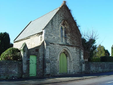
Holloway’s Guide of 1848 records that the chapel was dedicated to St Paul. Ryde Cemetery is older than any of the Island’s other municipal cemeteries and predates the Burial Act of 1853 by over 10 years. (The next oldest municipal cemetery is at Northwood – established in 1856). In 1860 the Ryde Town Commissioners became a constitutional burial board and took over the cemetery. Minutes of the Ryde Burial Board meetings are held at the IW County Records Office.
By the late 1850s this cemetery also was beginning to fill up and there was a need to find more land. A number of options were considered but eventually about four acres of land land to the north and west of the Old Parish Cemetery was purchased from the Player estate a cost of £250 per acre.
This extension is now known as The Old Cemetery (OC).
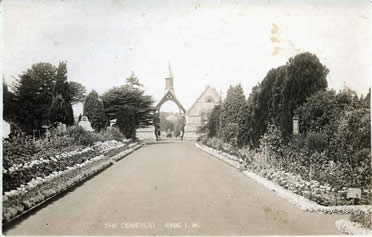
The central driveway and main paths were laid out at this time and in 1861 a pair of new chapels joined by a covered porch were erected. The south chapel was for Church of England worshippers and the north for Non-Conformists. The central driveway passed under the porch and also surrounded the chapels with a turning circle. The porch originally had a bell tower with low toned bell that would be slowly tolled for funerals. The bell was removed following complaints from neighbours about the noise in 1870 and the bell tower was removed some time after that. Once the two new chapels were buils the original chapel to St Paul on West Street closed and it later became the town mortuary.
A portion of this extension to the Cemetery (The Old Cemetery) was set apart for the burial of Roman Catholics and was consecrated by Bishop Grant in 1863 (this portion being distinguished by a memorial cross). Another portion of the Cemetery was devoted to non-conformists.
In 1863, the lodge for the Cemetery Superintendent, was built, it is now in private hands.
The earliest phase of the cemetery is shown on a Ryde Town Commissioner’s Survey of 1854/55. The Ordnance Survey map, surveyed in 1862, and published in 1866, shows the first enlargement to the Cemetery. The two chapels are shown on this map and labelled as ‘Episcopal Chapel’ and ‘Dissenters Chapel’. The original Chapel of St Paul on the eastern edge of the Cemetery is labelled as ‘Episcopal Chapel (Old)’. The lodge is also shown and labelled on this map. At the time when the map was surveyed the roads to the north and south of Ryde Cemetery had been laid out, but houses had not yet been built. To the north of the Cemetery several sand pits are shown. The original part of Ryde Cemetery had been laid out on the site of an old sand pit.
A further large extension to the cemetery was made in 1881, again with land purchased from the Player estate, extending the burial ground as far as the Pellhurst Road boundary.
This section is now known as The New Cemetery.
The Ordnance Survey map of 1896 shows this extension and the map also shows the shelterbelt of conifers that still exists along the boundary with Pellhurst Road today. By this time houses had been built on three sides of the Cemetery, but the land to the south was still occupied by allotments and nurseries.
The Ordnance Survey map of 1908 shows minor changes to the path layout. In 1920 there was a proposal to extend the cemetery to the south but this did not happen. The 1939 Ordnance Survey map shows Adelaide Place and the Nurses’ Home had been built to the south of the cemetery, little change had taken place within the cemetery except for a further minor addition to the path network. The digitised Ordnance Survey map base updated in the 1990’s shows no further changes to the shape or size of the Cemetery. In 2002, the Nurses Home was demolished, and a development of new housing was built in the grounds.
Ryde Cemetery was administered by Ryde Borough Council from 1868 until 1974 and by Medina Borough Council from 1974 until 1995. since 1995 it has been administered by The Isle of Wight Council. The cemetery is full except for a few existing rights and spaces.
The Isle of Wight County Record Office holds the Ryde Borough Council records, which include material relating to Ryde Cemetery: the Minutes of the Ryde Burial Board from 1860-1872 (two volumes), the Minutes of the Cemetery Committee from 1858-1967 (six volumes), and the ledgers of the Burial Board from 1862-1943 (nine volumes). These records have been reviewed for information and extracts recorded on one page which can be found here: Ryde Cemetery History from Committee books.
Cemetery Restoration Works 2010
In 2010 the Isle of Wight Council carried out extensive restoration work in Ryde Cemetery in conjunction with the Heritage Lottery Fund: All three chapels were restored and a Heritage and Learning Centre was created in the two central chapels; new railings and gates, in a Victorian Style, were installed at the Pellhurst Road entrance; new wooden gates were installed at the West Street entrance, the central driveway and area surrounding the central chapels were improved; much of the boundary wall was repointed and some of the significant graves were restored.
Design and Layout
The original part of the cemetery, consecrated in 1842, lies in the southeast corner of the present site, with the Chapel of St Paul halfway along the eastern side of the original Cemetery area, with an entrance door opening onto West Street.
The First Edition Ordnance Survey surveyed in 1862/63 shows a central drive running west from the main entrance in West Street (then known as Cemetery Street) to the western end of the cemetery. A turning circle is shown in the centre of the cemetery surrounding the two chapels and another turning circle is shown at the western end of the drive. There are paths parallel to the central drive on the north and south sides of the cemetery; numerous paths running from north to south intersect these paths along the main axis of the cemetery. In the southeast corner of the cemetery, which was the original part of the cemetery laid out before 1842, the layout of the paths shown on the 1866 map differs from that elsewhere in the cemetery. The 1860’s map shows the cemetery to have been thickly planted with trees along the north-south paths except in the southeast corner where fewer trees are shown.
The 1881 western extension to the cemetery shown on the Ordnance Survey of 1896 is at a slight angle to the earlier part of the cemetery because of existing property boundaries. A path shown within the extension on the 1896 map had been re-aligned by 1908, the date of the next large scale Ordnance Survey. The 1908 map shows the main west-east axis of the cemetery maintained by the extension of the central west-east drive, through the new portion of cemetery as far as the western boundary, and two subsidiary paths laid out to the south of a turning circle in a rectilinear pattern. Two further paths had been added to this rectilinear plan by the time of the Ordnance Survey of 1939.
The present layout of Ryde Cemetery maintains the central west-east drive with turning circles and a simple grid of paths parallel to this drive and at right angles to it. The numerous small paths running north-south that are shown on the 1860’s Ordnance Survey are no longer present although some subsidiary paths remain in the oldest part of the cemetery at its south east end. The northeast quarter of the cemetery is at a lower level than that of the surrounding land. This is due to previous use of the land as a sand pit.